The Pader sources from the perspective of landscape sciences

Landscape history

Zustand der Fließgewässer (2020); Kartenvorlage: Webatlas von GEOBASIS NRW, 2020, (govdata.de/dl-de/zero-2-0); Entwurf und Zeichnung: M. Hofmann 2020

Paderborn lies at the intersection of different landscapes: at first glance, flat riverine landscapes extend to the north, while mountainous areas rise to the south. This refers to the major landscape units, the North German Lowlands and the Central German Uplands and Hills, which meet in the Paderborn area and can be separated from each other by the „terrain bend“. While the transition between the North German Lowlands and the rising Central German Uplands and Hills is often somewhat blurred by alluvial fans, flowing earth accumulations and other loose material deposits that lie in front of the uplands, it proves to be clearly recognisable in the section between the Almetal in the west and the valley of the Krumme Grund[1] in the east, i.e. in the closer vicinity of Paderborn. This is because here such overlays recede, so that the rock layers built up of limestone, which are characteristic of the area to the south of Paderborn, the Paderborn plateau, reach right up to the kink in the terrain.[2] A clear slope has formed, which can currently be seen particularly strikingly below the cathedral and the Abdinghof church as well as in front of the city administration building with a view of the Börne-Pader spring basin.[3] At the transition to the flat terrain, productive springs[4] pour considerable amounts of water. A contour map drawn meticulously by the former town planning officer Bernhard Ortmann in 1977, which is reproduced in Figure 1, illustrates the terrain situation very aptly.[5] The main springs emerge in two niches formed by retrograde erosion in the overlying limestone.

Topography Paderquellen
Topography Paderquellen, contour map by Bernhard Ortmann 1977 (Fig. 1), from: Ortmann, Bernhard: Die Ältesten Befestigungen innerhalb der Altstadt von Paderborn seit karolingischer Zeit. Zum Paderborner Jübiläum 777-1977; Felsberg 1977, p.10.

In addition to the natural features, the favourable traffic conditions are emphasised, which are said to have been of importance for early Paderborn in particular and to have given rise to foundation considerations. However, the situation seems to be more complicated: The intersection between the important west-east road, the „Hellweg“ (Duisburg-Dortmund- Soest-Paderborn-Magdeburg …), and the important north-south connection, the so-called „Frankfurter Weg“ (Frankfurt-Marburg-Korbach-Marsberg-Paderborn-Herford-Minden-Bremen), lay to the west of the spring outlets, in the area of the former settlement of Balhorn,[6] close to the Almefurt, which also seems plausible and comprehensible from topographical considerations. The „Karlsburg“, the first tangible Carolingian construction project in the Paderborn area, was built in 776 about 2.5 km further east, above the eastern spring niche,[7] close by, but not directly at the intersection of the long-distance roads and also not directly on the „Hellweg“, which – as was customary at the time without a precise route – can be assumed to be further south, approximately in a straight extension of today’s Bahnhofstraße and Westernstraße. Military and constructional considerations, i.e. military-strategic and supply-oriented considerations, possibly also aspects of property law, seem to have been decisive for the choice of this location. The location above the springs offered firm (rocky) and dry building ground, easy access to the water, suitable building material in the neighbourhood, to the west and east due to the spur location and to the north due to the slope and the wet apron at least some protection. Only to the south, artificial safety measures were necessary. Due to its natural features, this location offered many advantages: No other place on the „Hellweglinie“ (Hellweg line) between Geseke and Lippspringe could offer such conditions. Although there were springs in many places, albeit with a lower water supply, nowhere did the rock reach as far as the water outlets. This combination of features was recognised and used, and the distance to the important traffic routes was accepted. After the destruction (778) of the first Karlsburg by the Saxons, the reconstruction and the establishment of reinforced fortifications (probably with expansion of the area) took place, as well as the realisation of further buildings that could be used as a palace and ecclesiastical buildings.[8] Multiple royal sojourns and the holding of imperial assemblies required the construction of representative buildings and supply facilities. The establishment of the ecclesiastical organisation in the conquered Saxon territories and the transfer of missionary tasks, combined with the appointment of a bishop, made additional building measures necessary in the secured area at the „Karlsburg“. Through the construction of a large church, a monastery and the bishop’s residence, the original castle-palatinate site also developed into a cathedral castle. Craftsmen, traders and servants settled in the vicinity of the building complex, which was initially set up primarily for military and administrative purposes, as numerous excavations have shown.[9] Thus the demarcated and fortified area became the nucleus for the later urban settlement. To the south of the fortified area (in the area of Grube, Kötterhagen), sufficient building material could be obtained from quarries.[10] At the same time, these quarries provided an effective protective ditch to secure the area to the south, as the archaeological excavations in the area of Grube, Kötterhagen make clear: On the side facing Karlsburg / Domburg, the quarry walls were steeply developed „in contrast to the stepped and nest-like quarrying on the opposite … side.“[11]

The extended environment also proved to be favourable: the springs and the watercourses offered, in addition to the drinking water supply, the possibility of using service water, for example for tanning, laundry and bleaching, and for sewage disposal,[12] for cooling (with a year-round water temperature of 8-12° C), for providing fire-fighting water in case of fires, for fishing in the flowing waters and soon also for fish farming in created ponds, as well as for energy generation by water wheels, for example in the mills on the bunded drainage channels.[13] The wet areas that extended to the north were used as pasture and hay land. The tall beech-oak forests on the Paderborn plateau provided timber and firewood. As „Sundern“ (plots of land segregated from the general usufruct and transferred to private use), they were subject to special protection.[14] The sufficiently dry areas at the transition from lowland to upland and in the lower part of the upland served as farmland. Loess drifts or marly to loamy moraine deposits, comparable to conditions in the „Hellwegbörden“, as well as the fine-grained and sufficiently dry sediment accumulations near the surface in the central part of the alluvial fans[15] provided suitable land for arable use here.

The favourable combination of landscape features already led the author of the „Translatio S. Liborii“, when he tried to describe Paderborn and its surroundings towards the end of the 9th century, to speak of a „natural(is) … excellentia“ (an outstanding natural endowment),[16] and the „Urmeßtichblatt“ (original measurement sheet), which was recorded almost 200 years ago, still clearly shows the predominant landscape structure in the Middle Ages: The recorded field names „Balhorner Feld, Lohfeld, Gausefeld, Dörenerfeld, Lange Wenne or Steinacker“ and the name endings on „–berg“ (mountain) in the southern part as well as the designations „–holz“ (wood), „–loh“ (wetland), „–bruch“ (mire), „–wiese“ (meadow), „–bach“ (brook), „–teich“ (pond) or „–heide“ (heath) in the northern part, together with the signatures and area colours, which refer to moisture or sufficient dryness, are an expression of this different and very advantageous natural endowment.

The springs and the outflowing water deserve special attention. This is already indicated by the name „Paderborn“ = sources of the Pader. From a hydrological point of view, three aspects in particular need to be evaluated: the large number of springs, the amount of water discharged and the type of water outlets.

In this context, the formulation repeatedly taken up in many publications that „over 200 springs rise“ in Paderborn should not be taken too literally as far as the number is concerned, since it remains unclear under what conditions the count was made. What is defined as a separate spring? Should every crack in the wall from which water gushes out be counted as a separate spring, even though it is fed from the same fissure in the adjacent rock? How was the area to which the number refers demarcated, and finally, when was it counted? Many water seeps merge into each other, and they are subject to frequent displacements. Are only the water outlets in the city centre (inside the city wall) counted or also the many springs in the entire city area and its neighbourhood? The number of springs is highly dependent on the respective water level in the fissures of the rocky karst rock and on the height of the groundwater level in the unconsolidated rock: In wet periods when the water level is high and there is a large supply of water, considerable amounts of water also bubble up from higher-lying outlets, the so-called „Quickspringen“; they dry up when the water level falls, and even in the main springs, in the two large spring niches below the cathedral and the Abdinghof church, the discharges drop sharply and the water outlets decrease considerably.[17] The only thing that remains to be said is that Paderborn has a large number of springs that cause considerable water discharge all year round.[18] This sets Paderborn clearly apart from other places on the geologically determined Westphalian spring line (Essen-Dortmund-Unna-Soest-Erwitte-Geseke-Salzkotten-Lippspringe). The water outlets in the two spring niches below the cathedral and the Abdinghof area show the strongest discharge.

In contrast to the neighbouring places, Salzkotten-Uppsprunge or Bad Lippspringe, some of the springs in Paderborn are distinguished by the way the water emerges: In the two spring niches below the cathedral and the Abdinghof area, a large part of the water emerges in concentrated form from fissures in the solid rock, which here are overlaid and blocked off by layers of rock that are richer in clay and less permeable to water (Emscher marl).[19] There are no marsh or pond springs in these places, where the water slowly rises in the loose rock, collects in wet spots and ponds and only gradually finds an outlet via branching rivulets. The latter is the case, for example, in many places east of the old town, such as in the Niesenteich area or near Gut Krespohl (source area of the „Rothebach“, or Rothe brook). The Riemecke-Kolk and the springs in the Maspern area are also water outlets in the surrounding loose rock. They lie outside the old city wall, and they show how difficult it is to find solid building ground in such an environment.

[1] „In eastern Westphalia, …. one does not speak of a ‚valley‘, but of a ‚Grund‘ – the word is feminine in the dialect and in older land registers, … the Krumme Grund“; JOSEF ROHRBACH, Die Paderborner Feldmark. Flurnamen und Flurgeschichte (Schriftenreihe des Paderborner Heimatvereins, H. 1), 2. Aufl. Paderborn 1963, p. 34.

[2] The geological map 1:25,000, sheet 4218 Paderborn, and a „hydrogeological section through the subsoil of the urban area of Paderborn“ presented by Gert Michel in the explanations to this map (p. 94, Fig. 16) document the natural specifications; Geologische Karte von Nordrhein-Westfalen 1:25.000, Blatt 4218 Paderborn, edited by Klaus Skupin, published by Geologisches Landesamt Nordrhein-Westfalen, Krefeld 1982; GERT MICHEL, Hydrogeologie, in: Erläuterungen zu Blatt 4218 Paderborn, edited by Klaus Skupin, Krefeld 1982; (Geologische Karte von Nordrhein-Westfalen 1:25.000), Krefeld 1982, p. 92-107, Fig. 15-18, Tab. 10-15; KLAUS SKUPIN, Erläuterungen zu Blatt 4218 Paderborn, edited by Klaus Skulpin, Krefeld 1982.

[3] Photographically, this slope is well highlighted in LUDWIG MAASJOST/GERHARD MÜLLER, Paderborn. Das Bild der Stadt und ihrer Umgebung, Paderborn 1977, S. 22, Fig. 18, p. 34ff.

[4] MICHEL (as in note 2).

[5] BERNHARD ORTMANN, Die Ältesten Befestigungen innerhalb der Altstadt von Paderborn seit karolingischer Zeit. Zum Paderborner Jubiläum 777-1977, Felsberg 1977, p. 5-10.

[6] MANFRED BALZER, Paderborn im frühen Mittelalter (776-1050). Sächsische Siedlung – karolingischer Pfalzort – ottonisch- salische Bischofsstadt, in: Das Mittelalter. Bischofsherrschaft und Stadtgemeinde, hg. v. Jörg Jarnut (Paderborn. Geschichte der Stadt in ihrer Region, Bd. 1), Paderborn 1999, S. 2-118, hier S. 6, Abb. 1; GEORG EGGENSTEIN, Die Ausgrabungen des mittelalterlichen Hellweges in Balhorn bei Paderborn, in: Archäologie im Paderborner und Corveyer Land. Schlaglichter auf 6000 Jahre Geschichte, hg. v. Georg Eggenstein (Heimatkundliche Schriftenreihe/Volksbank Paderborn, H. 34), Paderborn 2003, S. 22-31, hier S. 22ff.

[7] SVEVA GAI, Von der Pfalzanlage Karls des Großen zur Bischofsstadt. Die Topographie der Domburg zwischen dem 8. und dem 13. Jahrhundert, in: Stadt Paderborn, published by Landschaftsverband Westfalen-Lippe and Stadt Paderborn, edited by Heinrich Otten (Denkmäler in Westfalen, Bd. 2.1), Petersberg 2018, p. 39-50; WILHELM GRABE, Die Geschichte der Stadt Paderborn, in: Stadt Paderborn, published by Landschaftsverband Westfalen-Lippe and Stadt Paderborn, edited by Heinrich Otten (Denkmäler in Westfalen, Bd. 2.1), Petersberg 2018, p. 51-73; SVEN SPIONG, Paderborn aus archäologischer Sicht. Von den ersten Siedlern bis zur geplanten Stadt im 12. Jahrhundert, in: Stadt Paderborn. published by Landschaftsverband Westfalen-Lippe and Stadt Paderborn, edited by Heinrich Otten(Denkmäler in Westfalen,Vol. 2.1), Petersberg 2018, p. 15-38.

[8] BALZER (as in note 6), pp. 13.; GAI (as in note 7).

[9] Cf. in summary SPIONG (as in note 7), p. 15-38.

[10] SVEVA GAI/BIRGIT MECKE, Est locus insignis… Die Pfalz Karls des Großen in Paderborn und ihre bauliche Entwicklung bis zum Jahre 1002. Die Neuauswertung der Ausgrabungen von Wilhelm Winkelmann in den Jahren 1964-1978, Vol. 1 (Denkmalpflege und Forschung in Westfalen, Vol. 40,1-2), Mainz 2004; SVEN SPIONG, Von der bischöflichen Residenz zur mittelalterlichen Stadt. Die Stadtgenese Paderborns im Spiegel neuer archäologischer Ausgrabungen, in: Bischöfliches Bauen im 11. Jahrhundert. Archäologisch-historisches Forum, edited by Jörg Jarnut/Ansgar Köb/Matthias Wemhoff, (Mittelalter Studien des Instituts zur Interdisziplinären Erforschung des Mittelalters und seines Nachwirkens, Vol. 18), München 2009, p. 173-190; ULRICH KAPLAN, Der mittelalterliche Steinbruch des Bischofs Meinwerk und das Unterconiacium (Oberkreide) bei Paderborn (südöstliches Münsterländer Kreidebecken), in: Geologie und Paläontologie in Westfalen 83, 2012, p. 5-51.

[11] KAPLAN (as in note 10), p.  5-7.

[12] Until the 19th century, household waste and faeces, as far as they were not taken to the nearby fields or gardens for fertilisation, were usually disposed of via the flowing waters.

[13] MAASJOST/MÜLLER (as in note 3), pp. 128., Fig. 186f.

[14] BALZER (as in note 6), p. 7, 117.

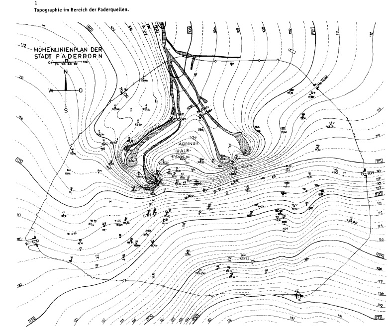
[15] For explanations on alluvial fans cf. MANFRED HOFMANN, Krumme Grund. Ein folgenreicher Eingriff in einen Wasserlauf im Südosten von Paderborn, in: Die Warte, Nr. 177, 77, 2018, p. 29-30.

[16] ALFRED COHAUSZ, Erconrads Translatio S. Liborii. Eine wiederentdeckte Geschichtsquelle der Karolingerzeit und die schon bekannten Übertragungsberichte mit einer Einführung, Erläuterungen und deutscher Übersetzung des Erconrad (Studien und Quellen zur Westfälischen Geschichte, Vol. 6), Paderborn 1966; BALZER (as in note 6), p. 4f.

[17] BERNHARD DACHNER, Beobachtungen zum Abflußverhalten der Pader und der Paderquellen, in: Südost-Westfalen. Potentiale und Planungsprobleme einer Wachstumsregion (Spieker. Landeskundliche Beiträge und Berichte; H. 35), Münster 1991, p. 65-82; MANFRED HOFMANN, Quellen in Paderborn. Entstehung, Bedeutung, Schutz, in: Le Mans und Paderborn. Zwanzig Jahre Partnerschaft zwischen der Université du Maine und der Universität Paderborn (Paderborner Geographische Studien, Vol. 5), Paderborn 1993, p. 25-41.

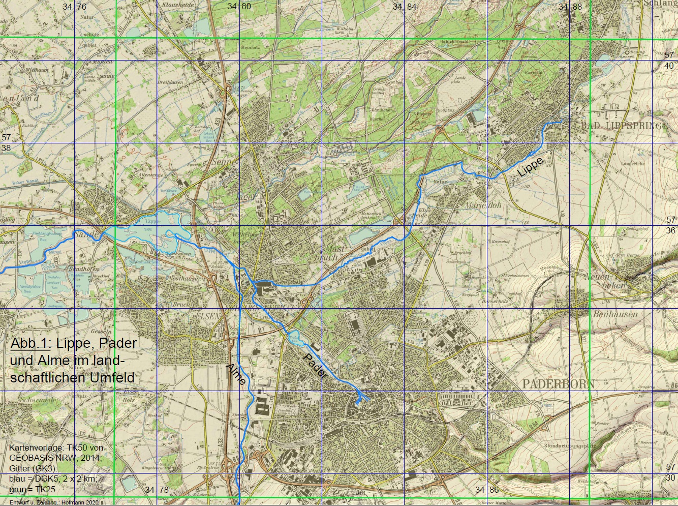
[18] At the level measuring point below the Padersee, where the water from all sources, including those draining via the Rothebach, and a large part of the rainwater runoff from the urban area have come together, a discharge of between 4-6 m³/s is usually determined, with a downward trend in recent times.

[19] MICHEL (as in note 2).

Learn more about the Landscape history of the Pader

Download essay

This is an excerpt from an essay by the geographer Prof. Dr. Manfred Hofmann. The original title of the essay is: „Anmerkungen zur Frühgeschichte Paderborns aus geographisch - landschaftskundlicher Sicht“ and was published in „Westfalen 97 (2019)“. Should you have further interest in the landscape history of the Pader, we recommend downloading the complete essay (PDF file).

To the contact form

Have you discovered a topic related to the Pader that has not yet been mentioned? We would be delighted if you would help us to bring „light into the darkness“. So please feel free to send us your own articles about the Pader!