Intervention in flowing waters – landscape changes to the Pader and surrounding area

Landscape history

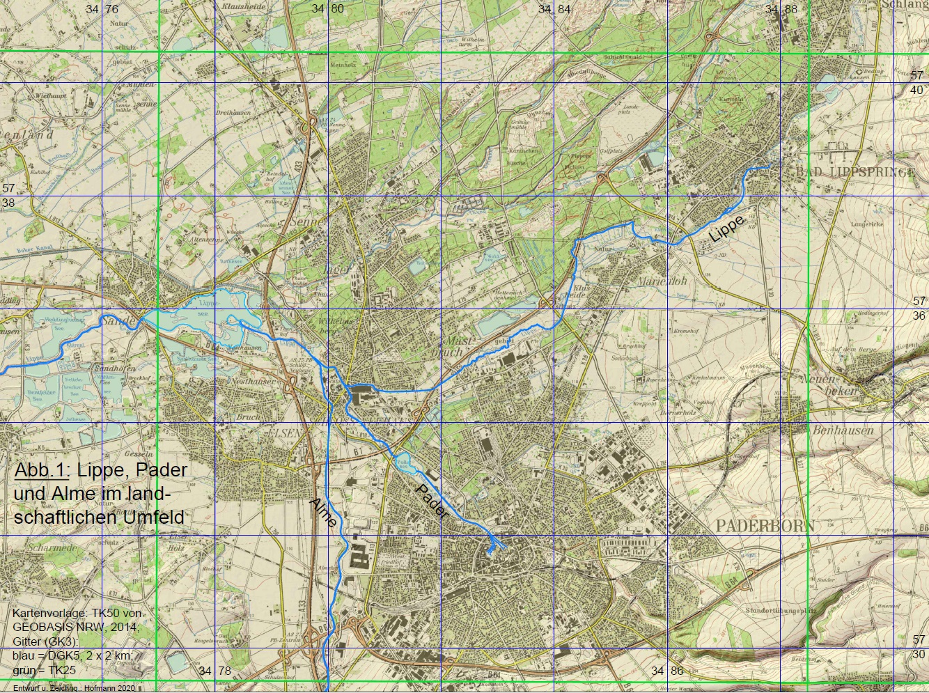
Pader, Lippe und Alme im landschaftlichen Umfeld;
Kartenvorlage: TK50 von GEOBASIS NRW, 2014; Gitter (GK3): blau DGK5, 2x2 km; grün= TK25; Entwurf und Zeichnung: M. Hofmann 2020

Flowing waters are in close interaction with their surroundings: interventions in the water bodies have an impact on the landscape, and vice versa, changes in the landscape influence the water bodies. The example of the Bad Lippspringe – Paderborn – Schloss Neuhaus area is intended to illustrate this interplay. By analysing and retracing individual interventions, the landscape situation before these interventions can be illuminated and explanations can be found for the current state, which in part gradually developed over the course of many centuries; in some places it is even possible to look forward to future developments. The most important watercourses in the area are the Lippe and the Pader. Fig. 1 provides a topographical overview of the above-mentioned watercourses and their integration into a larger landscape framework.

Pader, Lippe and Alme in the landscape environment
Pader, Lippe and Alme in the landscape environment (Fig. 1) Map template: TK50 from GEOBASIS NRW, 2014; grid (GK3): blue DGK5, 2x2 km; green= TK25; design and drawing: Hofmann 2020

Pader-Lippe Complex

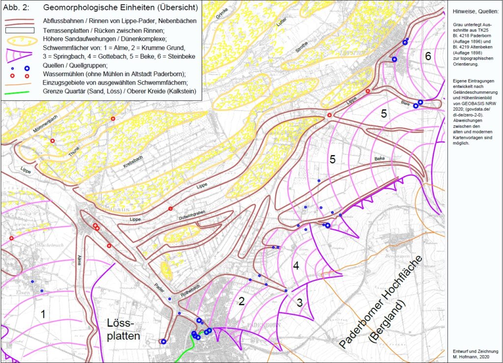
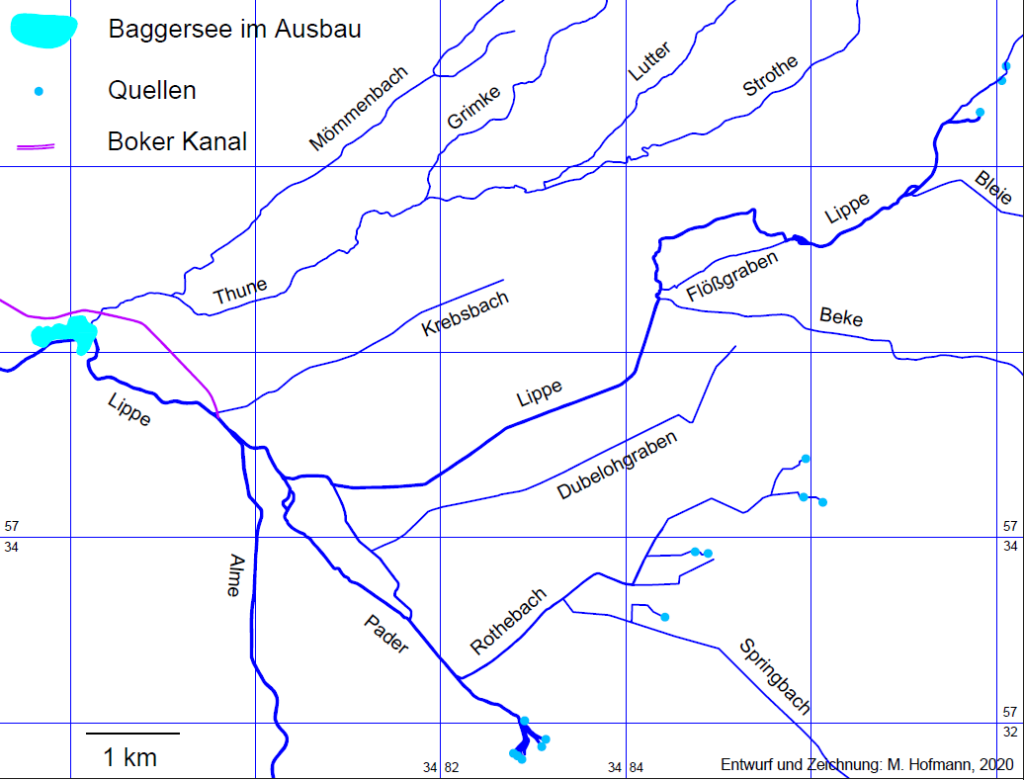
Between the Lippe bend near Neuhaus-Sande and the centre of Paderborn, on the left-hand side only two watercourses flow into the northwest-facing section of the river, namely the former small Riemekebach close to the west of Paderborn’s old town, which has unfortunately disappeared into pipes of the sewerage system today, and the Alme coming from the south. On the right-hand side, however, there are numerous tributaries. They come from a north-easterly direction, run roughly parallel to each other and meet the north-west-facing course of the river roughly perpendicularly (Fig. 2 and 5). Between the Lippe bend and Neuhaus these are the Mömmen-, Thune- [3] and Krebsbach as well as the northern (= western) arm of the Lippe coming from Lippspringe. Further in the direction of Paderborn, ditches and former watercourses are added, which were associated with the southern (= eastern) arm of the Lippe in Part I, in particular the Dubelohgraben and the Rothebach (Fig.2). The northwest-facing course can be seen as a central collecting artery, which receives all the tributaries mentioned and discharges them in bundles. In the middle section of the northwest-facing watercourse, a somewhat higher sediment bank has formed. It begins near today’s Padersee, and it extends into the gardens of Castle Neuhaus. It causes the northwest-directed collecting vein to split into two arms. Below the sediment bank, both arms reunite and then flow together towards Sande (Fig.2).

Geomorphological units (overview) (Fig. 2), design and editing: Hofmann 2020

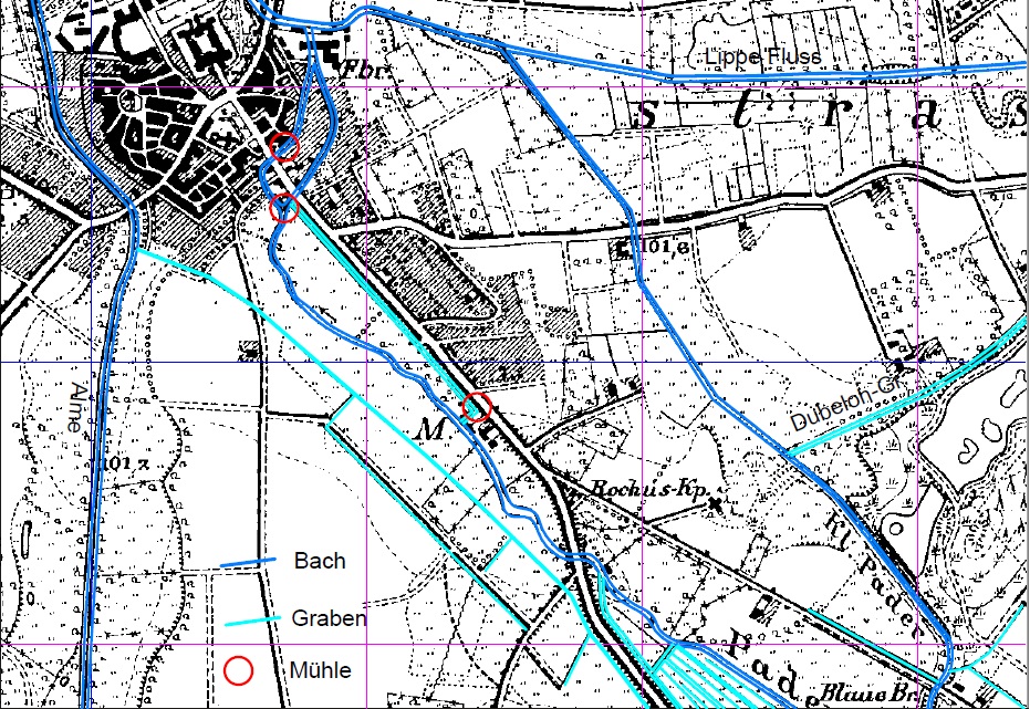
The watercourses on both sides of the sediment bank have undergone major changes due to human intervention: The western arm was supplied with the greater volume of water, as it was chosen to become the energy supplier for several water mills. For this purpose, its course has been widened, the outflow forced into a narrow artificial bed, enclosed in stretches by dams on both sides and guided so that its water level has a lower gradient than the depth contour of the valley, so that the river gradually reaches the crest of the sediment bank, which was desired in order to achieve the greatest possible energy potential for powering mill wheels. This artificial watercourse, which currently goes by the name of Pader, should better be called „Mühlenpader“ (Mill Pader) or simply „Mühlenbach“ (Mill brook). There is hardly anything left of the original watercourse on the valley floor west of the sediment bank. To drain off the moisture that collects at the bottom of the valley, a straight drainage ditch was created that leads directly to the Alme. This ditch is clearly visible on the TK25 sheet 4218 Paderborn of 1896 (new survey) (Fig.10).

Water drainage from the Pader to the Alme
Water drainage from the Pader to the Alme (Fig. 10); map template: TK25 sheet 4218 Paderborn, edition 1896; grid according to DGK5, 500x500 m, GK3; design and editing: Hofmann 2020

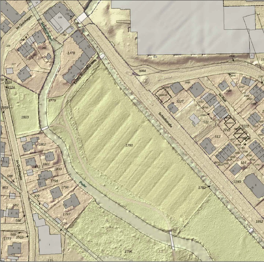
The „Walkemühle“ (fulling mill) , which is no longer in use today (STRÖHMER 2019: 8), was built on the Mühlenpader about 500 m south of the „Paderborner Tor“ in Neuhaus (Fig. 10). At this mill, part of the Pader water was already diverted from the river course, which was already raised there, to the lowest point of the valley. After exploiting the gradient, the tailwater was led along the western edge of the sediment bank, in a newly created ditch directly next to the road from Paderborn to Schloss Neuhaus („Schloss-Straße“). This drainage ditch was placed completely at the edge of the higher sediment bank and the transition to the ridge was further divided by material removal [4], in order to extend the formerly highly valued raftable meadow area on the valley floor as much as possible. The former ditches for the inflow and outflow of the raft water can still be clearly seen in many places in terrain surveys with the laser scanning method (Fig. 11).

Former raft meadows on the Pader / Schloss Neuhaus
Former raft meadows on the Pader / Schloss Neuhaus (Fig. 11); Source: GEOBASIS NRW, 2020, govdata.de/dl-en/zero-2-0

At the Paderborner Tor, at the entrance to the old settlement of Neuhaus, there were at least two more water mills (Fig.10) and a device for operating a fountain in the castle courtyard, a so-called „Wasserkunst“ (waterworks) (STRÖHMER 2019). The mills were located – like parts of the old settlement around the church and the castle with parts of the Baroque garden – on the narrow ridge between the arms of the Pader, i.e. somewhat higher and drier. The water was fed to the mill wheels via the raised and somewhat dammed Pader between the dams on both sides, as already explained, and the water was drained via ditches to the river arm east of the sediment bank or to the Lippe. The drainage ditches cut through the ridge and were constructed in such a way that the greatest possible difference in height could be achieved between the headwater and tailwater. The runoff from the fulling mill was also channelled into the ditches for the discharge of the tailwater (Fig.10 and 11). The watercourse to the east of the sediment bank atrophied, as much of the water originally flowing here was taken away from it. It was given the name „Kleine Pader“. Between 1830 and 1890 it was also transformed into a straight drainage ditch, as documented by the comparison of the original cadastral surveys (around 1830) or the original table sheet (1837) with the new survey of the TK25 (1896). The situation towards the end of the 19th century is shown in Fig. 10.

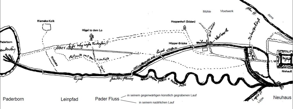
The Pader between Paderborn and Neuhaus after Grothaus 1680
The Pader between Paderborn and Neuhaus after Grothaus 1680 (Fig. 12); Source: Koch, J. 1977, p. 248f.; modified: reduced, translation added.

Josef Koch (1977: 248 f), who evaluated a sketch map „by Johannes Grothaus, S. J., from the time around 1680“ also came to the conclusion that the Kleine Pader represents „the old course of the Pader as it was made by nature“, and that today’s larger watercourse indicates „the artificially created course of the river, which was moved to the SW and canalised to raise the water level (waterworks) and because of the construction of the mill and a towpath“. Fig. 12 reproduces the map sketch reproduced by Koch in a reduced and somewhat modified form. The towpath assumed by Koch, which in his opinion offered the possibility „to pull a watercraft upstream from the bank by horse or human power using a tow rope („Treidel“)“ (ibid.) and to make the Pader navigable, can, however, only be realised on the Mühlenpader between Paderborn and the Neuhaus mills due to the morphological conditions described above. This is because there were no locks at the mills through which ships could have been lifted from the lower water to the upper water or vice versa. For a shipping route from Neuhaus to Paderborn, only the Kleine Pader would come into question, as it was the only one that allowed a continuous journey between the places mentioned. For the Kleine Pader, Koch’s assumptions mean that it at least had a higher discharge before the Mühlenpader was extended or possibly even took up the main discharge.

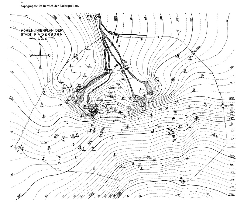
Further up the valley, between the sediment bank and the Paderborn city wall, there is a section of the Pader that will be referred to here as the upper Pader. In this section, the watercourse, which originally also meandered strongly there, was altered by damming devices as well as numerous inflow and outflow ditches for meadow watering. The created raft meadows temporarily occupied the entire artificially altered valley floor (TK25 sheet 4218 Paderborn from 1896). Later, flood protection and recreational facilities (Padersee) were created in the abandoned raft meadows and larger sections facing the Fürstenweg were used as settlement areas. In the estuary area of the Rothebach (1878-1912), the „Curanstalt Inselbad“ with a spa hotel and spacious parks (MICHEL 1992; VÖLKEL et al. 2014) was located. Mineral springs (Ottilien-, and Marien-Quelle) that came to light there were used as remedies. The section of the Padertal between the Fürstenweg and the city wall also served for a time as a meadow area with rafting facilities. The water run-offs from the springs in the centre of Paderborn caused difficulties for the city wall on the edge of the old town. For from a defence point of view, any interruption of the wall in earlier times represented a neuralgic point. In order to minimise the danger, the headwaters of the Pader were brought together within the walled area and channelled through the city wall at one point. The bundled diversion of the spring water was also continued outside the city wall over a short distance. The changes to the watercourses within the walled old town area, where they were constricted in many places by walls or other buildings, where spring ponds were dammed and canal-like routes to the numerous water mills were created, will not be elaborated on, because their discussion would require a very small-scale consideration, which cannot be achieved with the dimensionality chosen here.

„Begradigung und Verkürzung der Fließgewässer um 1980“
„Begradigung und Verkürzung der Fließgewässer um 1980“ (Fig. 5), map template: TK25 sheet 4218 Paderborn, continuation status 1977 = before the start of renaturation measures; grid in sheet section of DGK5, 2 x 2 km, coordinates according to Gauss-Krüger, zone 3, design and drawing: M. Hofmann 2020

In 1979-80, the „Padersee“ (Pader lake) was created in the „Paderaue“ (Pader meadow). It was intended to serve flood protection and recreation. However, it was problematic that the Pader was channelled through the lake. As a result, the hollow form dredged for the lake became a trap for the coarse particulate sediments transported by the river as well as for suspended and floating matter. While the floating matter, wood, plastic and various other floatable wastes that entered the river in the urban environment floated on the lake surface and were driven by the prevailing winds mainly to the eastern shore areas, where they required regular cleaning measures, the clods and heavier substances as well as a considerable part of the suspended matter settled in the lake. This led to progressive sedimentation, easily recognisable by the considerable alluvial fan that formed below the river mouth and by the increasing shallowing of the water depth. The substances transported by the water in dissolved form, a high percentage of which are very effective plant nutrients – they come to a large extent from the soils on the Paderborn plateau, where they sink after precipitation in crevices and in stream meanders and are brought to the surface again with the spring water, but also from the excretions of the numerous water birds – promoted eutrophication, so that in the shallow, well-sunlit standing water there was strong algae growth, which accelerated the silting-up process and led to odour nuisance. Below the lake, the river began to load itself with sediment again, so that the bed deepened there (deep erosion). In addition, the eutrophic runoff from the lake caused pollution of the tailwater, which could only be reduced slowly. Since the ecosystems of flowing and standing waters differ greatly, the river ecosystem suddenly had to change into a standing water ecosystem after entering the lake and back into a river ecosystem after passing through the lake. The necessary conversions in each case, exacerbated by the indicated pollution, caused difficulties, which resulted in considerable disturbances in both systems. A second lake was created at the Lippe bend in Neuhaus-Sande by wet excavation for sand and gravel extraction, the Lippe lake. It too was originally created as a flow-through lake, which led to the same problems as those indicated for the Padersee. Differences only arose due to the size and depth of the facility. They led to delays in the sequence of development steps and differences in the dimension of the pressures. In order to alleviate the problems, in the meantime, at great technical and financial expense, flood diversion facilities have been completed for both lakes, which allow the lakes to be disconnected from the constant flow and the corresponding sections of the river courses to be diverted past the edge of the lake. Although the new bypasses appear relatively artificial in sections due to the spatial constriction, they contribute to reducing the deficiencies mentioned above and ensure unrestricted passability, which is a prerequisite for the development of near-natural watercourses and their ecosystems.

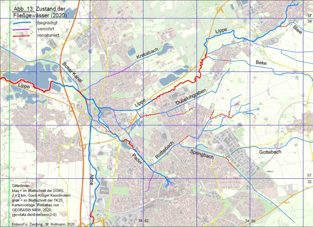
State of flowing waters (2020)
State of flowing waters (2020) (Fig. 13); design and drawing: Hofmann 2020

In addition to the flood control structures at both lakes, since the 1980s measures for renaturation have been initiated at several locations in the flowing waters (BZRG DT 2018; NZO 2013_2; NZO 2014; WOL 2013; 2015). Fig. 13 shows the larger altered sections, as of mid-2020. They stand out well from the straight courses from earlier times due to their richness in meanders. Admittedly, only limited sections could ever be included in the elaborate efforts. The most important sections are the Pader and Lippe lakes and the measures along the Lippe between Marienloh and Schloss Neuhaus. The renaturation approaches at the smallest water bodies, for example at the „Rothebach“ or „Springbach“, demonstrate well-intentioned efforts. Unfortunately, the new channel beds lack flowing water for long periods of the year.

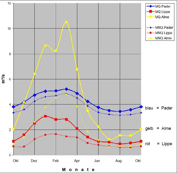
The discharge in the upper Lippe is largely determined by the inflow from Paderborn, the Pader. In low-water situations, it provides the largest part of the total discharge, and even in medium-water conditions it still achieves great significance. Recent gauge measurements show that the Pader, with a mean discharge (MQ) of 4.27 m³/s, almost reaches the mean discharge of the Alme, which is given as 4.64 m³/s (DGJ). According to measurements at the Neuhaus gauge before the confluence with the Pader, the Lippe has a mean discharge of 1.78 m³/s (DGJ). Only in flood situations do the discharges of the Alme and Lippe temporarily exceed the discharge of the Pader, because the former has considerably larger above-ground catchment areas. However, the mean values (MQ) given require a critical assessment. This is because they do not adequately express the discharge fluctuations. While the Alme and Lippe show large fluctuations, the Pader shows only little variability, so that the water flow in the upper Lippe, after the confluence of the three rivers, is mainly determined by the Pader over long periods of the year (Fig.14).

Mean discharge Pader Lippe Alme in Schloss Neuhaus
Mean discharge Pader Lippe Alme in Schloss Neuhaus (Fig. 14); source: Deutsches Gewässerkundliches Jahrbuch, Rheingebiet, Teil III, Düsseldorf: LAWA NRW, 2009

In earlier centuries, the amount of water flowing into the upper Lippe via the Pader was even greater. Unfortunately, this statement can only be proven by circumstantial evidence, because corresponding measurements are missing. But the findings are clear: in former times, part of the Lippe water flowed via the drainage channel east of Marienloh in the direction of Paderborn and thus to the Pader. This drainage channel also received the runoff from the alluvial fan in the Beke as long as the breakthrough through the sand ridge between the „Lütkeheide“ and the „Klusheide“ in Marienloh did not exist. Likewise, the water drainage from the Dubelohgraben to the western arm of the Lippe (Part I) was missing. The water draining via the eastern arm of the Lippe used to be missing from the western arm, and it increased the discharge of the Pader. In addition, the discharges of the Rothebach and Springbach were much greater and more constant because the discharge-reducing measures of modern times were not yet effective. In addition, precipitation as well as domestic and commercial wastewater from the area of the urban settlement was discharged via the Pader and not directly to the sewage treatment plant at Sande via sewer lines, as is largely the case today. These discharges via the sewage system bypass the natural discharge via the Pader and are not recorded by the measurements at the gauges mentioned. The Pader springs themselves also conveyed larger quantities of water in earlier times, as the sealing of the stream meanders in their catchment area, the Paderborn plateau, was less advanced and the extensive drinking and service water withdrawals from the deeper layers of karst rock, which according to LÖHNERT (1990) also contribute considerably to the reduction of spring discharges, had not yet been made.

Most of the water flowing down the Pader comes from the numerous springs that come to light in the centre of Paderborn. They are collectively referred to as the Pader springs. In addition to the volume of water, these springs, because they are fed from an underground reservoir that delays runoff peaks and dampens them in terms of volume, ensure a strikingly balanced water flow in the Pader (Fig.14) and the entire upper Lippe: differences in runoff levels between the summer and winter half-years or the individual months in the course of the year are relatively small. In addition to the steady flow, the Paderborn springs are also gaining in importance in terms of water temperature. Since the water emerging after the ground passage in the springs has temperatures above 8 °C all year round [5] and the adjustment to the ambient temperature is slow due to the physically determined high heat capacity of the water and the large volume of water, the spring discharges ensure that the stretches of water they influence have a balanced heat balance all year round, with cool temperatures and little fluctuation: In summer, the spring water prevents rapid heating of the flowing wave, and it has a cooling effect on the near-river environment. In winter, on the other hand, the heat stored in the water prevents a rapid drop in water temperature. The spring water ensures that the stretch influenced by it does not freeze over even in severe winters [6], an observation that does not apply to the tributary streams and ditches flowing into the river due to their smaller water volume and their longer upstream course. If, in severe winters, one were to follow the flowing wave up the Lippe from the west, one would arrive in Paderborn. Thus, the springs in Paderborn decisively determine the character of the upper Lippe through the amount of water, the constancy and the annual variation of the flow as well as the water temperature. Together with the organisms living in and adapted to this watercourse, they give rise to an independent ecosystem that stands out from the ecosystems of the tributaries and from those of the middle or lower reaches of the Lippe.

[3] According to Figs. 2 and 5, there seem to be diverging views on the confluence of the Mömmenbach and Thunebach into the Lippe river. The divergent indications are caused by anthropogenic interventions: In order to operate a water mill, the discharge of the Thunebach was led via a newly created ditch to the Thune mill and diverted below the mill to the Mömmenbach in order to achieve a better energy yield (HOFMANN 2019). The original mouth of the Thunebach into the Lippe fell into disrepair.

[4] From Schloss-Straße, the difference in height between the valley floor with the ditch for the drainage of the underwater and the ridge rising by about 2 m is clearly visible. The slightly higher and thus drier area was already used as a site for buildings decades ago. On the south-eastern edge of this ridge is the Rochus-Kapelle (Rochus Chapel), close to the former border between the municipalities of Paderborn and Neuhaus, still on Neuhaus territory and close to the Kleine Pader, which was important for the water supply. The chapel provided a place to stay for sick people who were to stay away from the urban settlements (plague patients, lepers, etc.), and it was visited on the occasion of commemorative and petitionary processions.

[5] The water temperature of the springs in the centre of Paderborn varies depending on the air temperature in the seepage area, the duration of the water’s stay in the subsoil, the depth the water reaches on its way in the subsoil and, last but not least, the mixing of the water strands between the seepage point and the outlet point. The differences between the individual springs and spring basins are not very great, if the warm Pader is left aside. They range predominantly between 8 and 12 °C. Only the warm Pader exceeds this value, as it reaches 15 – 16 °C. However, its discharge is low compared to the total discharge of all springs, so that it has little influence on the average temperature of the Pader. Within the course of the year, the changes in water temperatures are also small. The fluctuations reproduce the course of the mean annual air temperature in a weakened and delayed manner, so that the higher temperatures are measured in autumn and winter, and the lower temperatures in spring and summer (DACHNER 1991; HOFMANN 1993; STILLE 1903). Due to the mixing of the water outlets, the water temperature of the Pader can be assumed to fluctuate only slightly between 8 and 12 °C throughout the year.

[6] Due to climate change, frozen watercourses are currently a rarity. This was different in earlier centuries. Until the middle of the 20th century, longer periods of frost with ice flows on rivers can be observed more frequently (BUND 2009; RENTEL 2019). For the water mills on the waters influenced by the karst springs in Paderborn, Neuhaus or Lippspringe, the absence of ice was a great advantage. They could work even in severe frost.

Auffenberg, Karl 2018: Die Heidekompanie und ihr Gebiet in der Stadtheide. ln: Heide-Focus 2018. 50 Jahre Heide-kompanie. Paderborn: Bürgerschützenverein Paderborn, 2018, p. 70-79, numerous figures

BZRG AR 2010: Lippeaue. Eine Flusslandschaft im Wandel. Arnsberg: Bezirksregierung Arnsberg, 2010, lV, 48 p., numerous figures

BZRG AR 2018: Schön & eigenwillig: Die Lippeseeumflut in Paderborn-Sande. Entwicklung von 2005 bis 2014. Arnsberg: Bezirksregierung Arnsberg, 2018, 36 p., numerous figures

BZRG DT 2018: An der Lippe geht es weiter … Fortführung der Maßnahmen ober- und unterhalb des Sander Lippesees. Informationsveranstaltung „10 Jahre Lippeumflut“ am 1. Okt. 2015 im Gut Lippesee. Detmold: Bezirksregierung Detmold, 2018, 28 p., numerous figures

Dachner, Bernhard 1991: Beobachtungen zum Abflußverhalten der Pader und der Paderquellen. ln: Südost-Westfalen: Potentiale und Planungsprobleme einer Wachstumsregion. Jahrestagung der Geographischen Kommission für Westfalen in Paderborn. Münster: Geographische Kommission für Westfalen, 1991, p. 65-82, 5 figures, 3 charts; (= Spieker. Landeskundliche Beiträge und Berichte; H.35)

DGJ 2006 ff: Deutsches gewässerkundliches Jahrbuch, Rheingebiet, Teil Ill. Düsseldorf: Landesamt für Wasser und Abfall Nordrhein-Westfalen (LAWA), Abflussjahre 2006 – 2009

Elbers, Bernhard 1998: 200 Jahre Paderborner Stadtheide: Chronik von der Hudezeit bis zur Gegenwart.o.O.; o.j.. (als Manuskript im Stadt- u. Kreisarchiv Paderborn einsehbar).

Evelt, Julius 1876: Über den Ursprung des Ortsnamens “Paderborn”. In: Zeitschrift für Vaterländische Geschichte und Altertumskunde (= Westfälische Zeitschrift), Vol. 34, 1876, Abt. 2, p.169-199

Feige, Wolfgang 2004: Wiesenbewässerung an der Alme und in ihren Nebentälern. ln: Die Warte, Nr.123, [=jg.65, 2004, H.3], p. 8-13, 9 figures

Füller, Matthias 2000: Flösswiesen in Lippe. Zur Technik und ökologischen Bedeutung einer fast vergessenen Wirtschaftsform. ln: Lippische Mitteilungen aus Geschichte und Landeskunde,Bd.69, 2000, p. 331-345, 6 figures

Geyh, Mebus A.; Michel, Gert 2000: Nachhaltige Bewirtschaftung des gespannten und gepumpten Karstgrundwasservorkommens im Paderborner und Bielefelder Raum nach isotopenhydrologischen Ergebnissen. ln: Steirische Beiträge zur Hydrogeologie, 51, 2000, p. 5-56, 27 figures, 6 charts

Grothmann, Detlev a.o. 2020: Chronik der Stadtheide Herausgegeben anlässlich des 100-jährigenJubiläums der Stadtheide-Vereinigung Paderborn e.V.. Erstellt von Detlev Grothmann unter Mitarbeit von Michael Drewniok und Dina Faassen. Paderborn: Verein, 2020, 94 p., maps, figures

Hofmann, Manfred 1991: Sedimenttransport in Fließgewässern. Probleme durch Hochwasserrückhaltebecken und andere wasserbauliche Eingriffe, erläutert an Beispielen aus dem Südosten Westfalens. in: Natur- und Landschaftskunde, Jg.27, 1991, H.4, p. 73-80, 4 figures

Hofmann, Manfred 1993: Quellen in Paderborn – Entstehung, Bedeutung, Schutz. ln: Le Mans und Paderborn. Zwanzig Jahre Partnerschaft zwischen der Université du Maine und der Universität Paderborn. Paderborn: Universität Paderborn, Fach Geographie, 1993, p. 25-41, 6 figures; (= Paderborner Geographische Studien; Vol.5)

Hofmann, Manfred 2019: Eingriffe in Fließgewässer: Beispiel Thunebach / Paderborn-Schloß Neuhaus. In: Die Warte, Nr.183, [=jg.78, 2019, H.4], p. 34-35, 3 figures

Hohmann, Friedrich Gerhard 1986: Bendesloh – Marienloh, Geschichte eines Dorfes. ln: Bendeslo -Marienloh: 1036-1986. Hrsg. anläßlich der 950-jahr-Feier des Stadtteils Marienloh von Engelbert Meyer. Paderborn: Stadt Paderborn, Stadtteil Marienloh, 1986, p. 7-84, figures

Kindl, Harald 1965: Padaribrunno, ein Versuch der Deutung des Ortsnamens von Paderborn. ln: WestfälischeZeitschrift (= Zeitschrift für vaterländische Geschichte und Altertumskunde), Vol. 115, 1965, Abt. 2, p. 283-394, 5 figures, 5 tables

Koch, Josef 1977: Frühe Verkehrsstraßen in der östlichen Westfälischen Bucht. Straßengeschichtliche Untersuchung zur Verkehrslage der Stadt Paderborn. Neuenbeken: Heimatverein Neuenbeken, 1977, XII, 291 p., 95 figures, maps; (= Schriftenreihe des Heimatvereins Neuenbeken; Nr.3)

Krakhecken, Maria 1939: Die Lippe <Fluß>. Münster: Coppenrath, 1939, VIII, 103 p., 14 figures in the text, 22 figures on 8 tables, 1 map-suppl; (= Arbeiten der Geographischen Kommission im Provinzialinstitut für Westfälische Landes- und Volkskunde; H. 2)

Löhnert, Eckehard P. 1990: Beitrag zur Geohydrologie des Karst-Aquifersystems von Paderborn (Nordrhein-Westfalen). In: Neues Jahrbuch für Geologie und Paläontologie. Abhandlungen, Vol. 181, 1990, H. 1-3, p. 519-530, 7 figures, 1 chart

Michel, Gert 1982: Hydrogeologie. In: Erläuterungen zu Blatt 4218 Paderborn. Von Klaus Skupin. Mit Beiträgen von Hans Mertens, Gert Michel, Egbert Seibertz u. Peter Weber. Krefeld: Geologisches Landesamt Nordrhein-Westfalen, 1982, p. 92-107,  figure 15-18, chart 10-15; (= Geologische Karte von Nordrhein-Westfalen 1:25.000)

Michel, Gert 1992: Die Curanstalt Inselbad bei Paderborn – ein vergangenes und vergessenes Heilbad. In: Tiefes Grundwasser in Paderborn. Paderborn: Stadt Paderborn, Stadtwerke, 1992, p. 129-138, 2 figures,  1 chart

Moritz, Gerhard 1997: Ehemalige Flößwiesen im Stadtgebiet von Paderborn und deren Bedeutung für den Naturschutz. In: Die Warte, Nr. 95, [= Jg. 58, 1997, H.4], p.9-12, figure

Moritz, Gerhard 1999: Flößwiesen: Biotopschutz im Einklang mit Kulturgeschichte. Hsrg.v. Amt für Umweltschutz und Grünflächen der Stadt Paderborn. Paderborn: Stadt Paderborn, 1999, 16 S., Abb.; (= Schriftenreihe Naturschutz und Landschaftspflege in Paderborn; H.4)

NZO 2013_1: Wiederherstellung der ökologischen Durchgängigkeit der Pader im Bereich des HRB Padersee. Antrag auf Genehmigung nach § 68 WHG. Nichttechnische Zusammenfassung. Im Auftrag der Stadt Paderborn. Bielefeld: Naturschutzzentrum Ostwestfalen (NZO), 2013, 14 p., figures

NZO 2013_2: Rothebach – Fließgewässer in Paderborn. Hrsg.v. Stadt Paderborn, Amt für Umweltschutz und Grünflächen. Bearb.v. NZO. Bielefeld: Naturschutzzentrum Ostwestfalen (NZO), 2013, 20 p., numerous figures

NZO 2014: Renaturierung der Lippe im Bereich Tallhof – Was hat sich inzwischen getan?. Gewässerkonferenz der Bezirksregierung Detmold am 19.11.2014. Bielefeld: Naturschutzzentrum Ostwestfalen (NZO), 2014, 63 p., numerous figures

NZO 2018: Umgestaltung des Rothebaches im Seskerbruch. Antrag auf Genehmigung nach § 68 WHG. Erläuterungsbericht. Im Auftrag des Stadtentwässerungsbetriebs Paderborn (STEB). Bielefeld: Naturschutzzentrum Ostwestfalen (NZO), 2018, 38 p., numerous figures

Stille, Hans 1903: Geologisch-hydrologische Verhältnisse im Ursprungsgebiet der Paderquellen zu Paderborn. Berlin: Königlich Preußische Geologische Landesanstalt u. Bergakademie, 1903, V, 129 p., 3 figures, 6 tables; (= Abhandlungen der Königlich-Preußischen Geologischen Landesanstalt und Bergakademie. N.F.; H. 38)

Ströhmer, Michael 2019: Wirtschaftsregion Pader 1950 – 1300. Neue historische Erkenntnisse und Perspektiven. Manuskript eines Vortrag vor Verein „Freunde der Pader“, (text + slides); Paderborn: Verein, 2019, 18 p., 1 suppl. with charts (www.freunde-der-pader>die-pader>wirtschaft-energie); viewed on 16 July 2020

Struckmeier, Wilhelm 1990: Wasserhaushalt und hydrologische Systemanalyse des Münsterschen Beckens. Düsseldorf: Landesamt für Wasser und Abfall Nordrhein-Westfalen (LAWA), 1990, 71 p., 21 figures, 13 charts in the text; 5 maps in suppl.; (= Wasser und Abfall: LWA Schriftenreihe; H. 45)

STUA 2005: Die Lippe bei Paderborn-Sande – jetzt wieder im Fluss. Broschüre: Hrsg.v. Staatliches Umweltamt Lippstadt. Gestaltet v. Naturschutzzentrum Ostwestfalen (NZO). Lippstadt: Staatliches Umweltamt Lippstadt (StUA), 2005, 21 p., numerous figures

Völkel, Jana; Fäßler, Peter E. 2014: Die Ottilienquelle, das Inselbad und die Curanstalt Inselbad bei Paderborn. Eine Dokumentation. Paderborn: Universität Paderborn, Historisches Institut, 2014, 34 p., 11 figures, Tab.

Learn more about the Landscape history of the Pader

Download essay

This is an excerpt from an essay by the geographer Prof. Dr. Manfred Hofmann. The original title of the essay is: „Beobachtungen im Gebiet Bad Lippspringe - Paderborn - Schloss Neuhaus: Eingriffe in die Fließgewässer - landschaftliche Veränderungen - Beziehungsgefüge Lippe und Pader“ and was published in „Mitteilungen“ by the „Naturwissenschaftlicher Verein Paderborn e.V.“ (2020). Should you have further interest in the landscape history of the Pader, we recommend downloading the complete essay (PDF file).

To the contact form

Have you discovered a topic related to the Pader that has not yet been mentioned? We would be delighted if you would help us to bring „light into the darkness“. So please feel free to send us your own articles about the Pader!