The Pader as a waterway

Trade & Transport & Services

Ausschnitt: bemannter Kahn auf der Kleinen Lippe an der alten Schloßbrücke, 1719 (Ortsansicht Neuhaus, Federzeichnung auf Pergament von J. C. Schlaun, Residenzmuseum Schloss Neuhaus, Foto M. Ströhmer 2019)

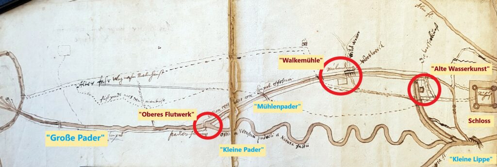
The function of the old arms of the Pader as waterways cannot be proven beyond doubt historically. A look at one of the oldest field maps, the „Abriß der Wege von Paderborn nach dem Nienhuiße“ by Johannes Grothaus S. J. around 1680, illustrates the natural obstacles to making the Pader navigable:[1] Starting from the three-arched water gate in Paderborn’s city wall – as documented pictorially in Schlaun’s prospectus of 1719 – the natural course of the old arm of the Pader was probably navigable by barges, at least to a limited extent, until it was divided into the „Mühlenpader“ and the „Kleine Pader“.

„Jesuit plan“ of the course of the Pader in the 17th century by J. Grothaus S. J., c. 1680 ("Abriß der Wege von Paderborn nach dem Nienhuiße", EAB Pb, AV, PA 123, fol. 15).

This is supported by its low-curvature course and Grothausen’s drawing of a „linpat“, which proves the existence or planning of a towpath for the late 17th century. At the branch of the man-made „Mühlenpader“ from the old arm, the towpath to Grothaus changed to the western bank of the Pader at the old „Flutwerk“. From here the straightened mill canal ran into Neuhaus.[2] This change from the Alte Pader („Kleine Pader“) to the Neue Pader („Mühlenpader“) was due to the topography in the middle section of the river. From the „Blaue Brücke“ (Blue Bridge) to its confluence with the Kleine Lippe, the Kleine Pader meandered a great deal. Its numerous tight bends and loops, but also its decreasing depth („Trockene Pader“, or „Dry Pader“), represented natural obstacles for all larger watercraft until the 1830s.[3] Continuous use of the Kleine Pader as a waterway for heavy loads can therefore almost be ruled out. This finding also applies in principle to the winding upper reaches of the Kleine Lippe.[4] This small river, too, was probably hardly navigable for larger barges.

[1] Annotated reprint in Koch, Frühe Verkehrsstraßen, p. 248f.

[2] North of the Old Waterworks, the „linpat“ led onto the later „Schloßstraße“ not far from the Paderborner Tor (Paderborn Gate).

[3] Cf. Paderborner Umlandkarte (Urmeßtischblatt 1837/38).

[4] Cf. reprint in Bremer, Eckhard: Die Nutzung des Wasserweges zur Versorgung der römischen Militärlager an der Lippe (Veröffentlichungen der Altertumskommission für Westfalen, Bd. XII), Münster 2001, Karte 2 (Ostteil) im Anhang. Friendly hint by Mr Siegfried Schröder, Paderborn.

Learn more about Trade & Transport on the Pader

Download essay

This is an excerpt from an essay by the historian Prof. Dr. Michael Ströhmer. The original title of the essay is: "Wirtschaftsregion Pader - Eine geschichtswissenschaftliche Skizze (1350-1950)". Should you have further interest in the economic history of the Pader, we recommend downloading the complete essay (PDF file).

To the contact form

Have you discovered a topic related to the Pader that has not yet been mentioned? We would be delighted if you would help us to bring "light into the darkness". So please feel free to send us your own articles about the Pader!