Freight and passenger traffic on the Pader

Trade & Transport & Services

For the uphill journey on the Pader, suitable towing vehicles were needed that could be equipped with a (foldable) tow mast. In order to be able to pull the ship against the often strong current, the towpaths on the banks had to be kept free of vegetation for people and animals at all times.[1] The felling of trees and bushes was therefore probably just as time-consuming and cost-intensive as the maintenance of the banks and paths; all works about which hardly any information has been extracted from archives so far.

Passenger navigation on the Pader, on the other hand, is documented in an early example. In the diary of Kasper von Fürstenberg (*1545 +1619), brother of the reigning bishop Dietrich, a presumed towboat trip from Neuhaus to Paderborn is recorded for April 1589: The prince sailed with a crowd of good-humoured guests „in the new ship up the Pader to Paderborn and down again“.[2] Whether the watercraft took its way across the Neuhaus Mühlenpader into the old arm of the Pader can only be assumed.

With the construction of the old waterworks (1596/97) and the dam of the Neuhaus fulling mill, hydraulic structures were probably built which made the continuous use of the Pader as a transport route more difficult. Whether heavy and bulky building materials for the bishop’s castle buildings in Neuhaus could be transported down the valley via the Pader can also only be speculated. The passage under several massive stone bridges, whose passages would have had to be of sufficient height, also appears problematic.[3] In Conrad Schlaun’s view of Neuhaus (1719), the passage of a Lippe bridge is indicated by the drawing of a small manned barge: its skipper stakes his vehicle, flattened at the bow, from the stern in front of the old, four-arched stone bridge. This structure contains a wooden drawbridge segment on the castle side, which would theoretically have allowed the passage of a towboat.[4] According to Gregor G. Santel, other pictorial sources confirm the assumption that there was already a small bridge harbour just below the confluence of the Pader and Lippe rivers in the 16th century. Its use as a local transhipment point for the upper Lippe shipping can be traced, with interruptions, to the beginning of the 20th century.[5] Whether the old bridge harbour also moved upstream with the baroque new construction of the Lippe bridge and waterworks (1752) remains to be assumed.

Detail: manned barge on the Kleine Lippe at the „Alte Schloßbrücke“ (Old Castle Bridge), 1719 (Neuhaus village view, pen and ink drawing on parchment by J. C. Schlaun, Residenzmuseum Schloss Neuhaus, photo M. Ströhmer 2019)

The modern connection of Neuhaus to the Lippe navigation, which the Prussian state had promoted in the 1830s, also indirectly affected the Pader as its water supplier. According to older plans of the chief president Ludwig von Vincke (1817), the water-rich Pader was to ensure that the recently developed upper reaches of the Lippe had sufficient water for barges and rafts.[6] A corresponding request from the Minden district government in July 1832 as to whether the Neuhaus miller Heinrich Bodenstab, as tenant of the royal grist mill, should be allowed to further narrow the Mühlenpader with new installations, was given a condition by the chief president: the inflow of Pader water into the upper Lippe had to be guaranteed day and night. For this reason, the grain miller was strictly prohibited from damming up the Pader water unnecessarily outside of the milling operation. Bodenstab had to scrupulously observe the dam marker set by the state, which was attached to a marker post above the Pader bridge:

„Also, for the purpose of timber rafting, the p. Bodenstab must rebuild the open channel located at the Domainen=Mühle [rye mill], now consisting of 2 openings of respectively 3.8 feet [approx. 1.10 m] and 4.6 feet [approx. 1.35 m] clear width […] into a passage of at least 6 feet [approx. 1.80 m] clear width.“[7]

After the completion of the last Lippe lock near Lippstadt (1830), all the constructional prerequisites had been created by the state to extend the waterway via Boke to Neuhaus.[8] Thus, on 7 June 1831, the first towboat of the company Baumann & Co. from Dorsten moored in front of the Neuhaus Lippe bridge. The barge, which was pulled against the current by horses, had a length of around 24 metres and was followed by four more ships over the next few days. In the town, the official traffic connection was celebrated with festivities, which were crowned by an opening trip by dignitaries to the nearby Thunehof.[9] However, similar imponderables soon became apparent when navigating the upper Lippe as on the neighbouring Pader: in Anreppen, the Lippe bridge, which was too low, blocked the descent of the five cargo ships that had been unloaded in Neuhaus a few days before. An increased water level of the river and the low clearance of the bridge caused the barges to be at a standstill for several days – an annoying stay, presumably not only from an economic point of view.

Schloss Neuhaus, old „Brückenhafen“ (bridge harbour) at the baroque Lippe bridge, early 20th century (Stadt- und KreisA Pb, photo W. Lange (Soest), Golücke Collection, S-M4D, no. 3628)

In addition to architectural obstacles, the ecosystem of the Pader itself also impaired its continuous navigability. The water levels in the Mühlenpader, especially in its lower reaches before Neuhaus, could fluctuate greatly from season to season. In winter and autumn there was a risk of flooding in the town,[10] while in summer the water levels were low, making it almost impossible to travel upstream to Paderborn. In addition, there was the well-known problem of riverbed sedimentation and the resulting erosion of the banks. The lack of maintenance of the Pader, the consequences of which were denounced by local residents to the authorities in the mid-19th century as „wildness“, completely devalued the river as a waterway. With the construction of the Boker-Heide Canal on the Lippe and the expansion of the railway network, the Pader and Lippe quickly lost their function as supraregional transport routes in the second half of the century. Consequently, the royal “Polizei=Reglement für die große und kleine Pader” (Police=Regulations for the Large and Small Pader) (1866) honours the river primarily as a „pre-flooding river“ for the Neuhaus mills. On the other hand, there are no provisions for regulating freight traffic or maintaining towpaths.[11] Fittingly, the state river regulations set the minimum clearance height of the Pader bridges at just two feet (approx. 0.60 m); an opening height that may have made it difficult for large barges to tow in the direction of Paderborn.[12] A last freight ship is said to have been seen on the upper Lippe in 1876.[13]

Destruction of the „Nepomukbrücke“ by the Neuhaus flood of 1890 (photo from: Gregor G. Santel, „Vornehm einfach – eingeschossig massiv“. Zur Baugeschichte des Hauses Scherpel in der Schloßstraße in Schloß Neuhaus, in: Die Residenz 52 (2012), pp. 39-57, here p. 41).

[1] Cf. using the example of Lippe navigation Bremer, Nutzung des Wasserweges, pp. 88.

[2] Quoted from Santel, Fons padulus, p. 4.

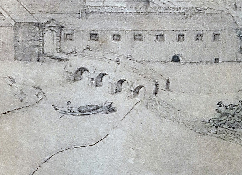
[3] Coming from Neuhaus, these were the following obstacles: the two inner-city crossings at the (a) four-arched bridge at the „Lipper Tor“, (b) the three-arched „Nepomukbrücke“  at the Paderborner Tor (Old Waterworks) as well as the (c) two-arched „Steinbrücke“ ( „pons lapideus“) at the upper reaches of the Pader shortly before the „Paderborner Wassertor“.

[4] Cf. C. Schlauns Neuhäuser Prospekt (1719).

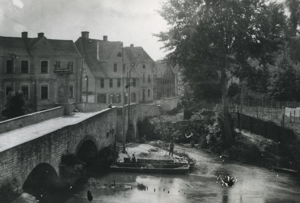
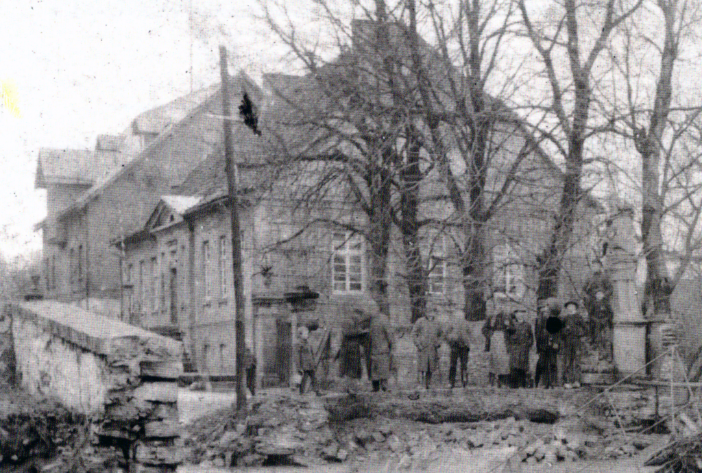
[5] Cf. a. o. photo taken around 1900 by W. Lange, Soest, Sammlung Golücke, StadtA Pb, S – M 4 D, No. 3628.

[6] On making the Lippe navigable in the 19th century, cf. Bremer, Nutzung des Wasserweges, p. 24ff. As early as 1830, Chief President von Vincke inspected Neuhaus as a potential final port for shipping on the Lippe. On 31 August 1832 he personally set sail from the Lippe bridge with a ship to travel via Boke to Lippstadt. Cf. excerpts from the local chronicle in Pavlicic, Michael: Neuhaus und die Lippeschiffahrt im 19. Jahrhundert, in: Die Residenz 92 (1989), pp. 11.

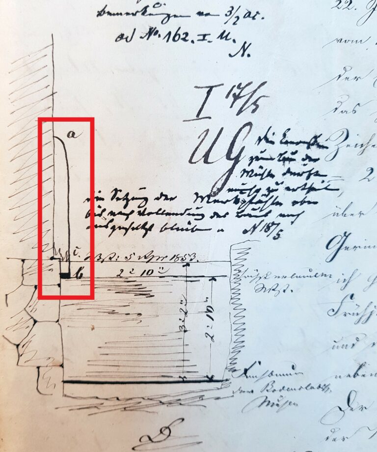
[7] Cf. copy of the assessment from the Minden government to Landrat von Spiegel in Paderborn, 2 March 1832. LA Detmold, M 1 I U, No. 660, unfol. A „Situations Plan von den F. Müller gehörigen an der Pader in Neuhaus belegenen Mühlen“ (Situation plan of the mills belonging to the F. Müller on the Pader in Neuhaus) records the alterations carried out in 1855. StadtA Pb(?), W6/ 66.

[8] Cf. Müller, Rolf-Dieter: Erstes Frachtschiff nach Schloß Neuhaus getreidelt. Strom- und Uferordnung für die Lippe, in: Die Warte 46 (1985), p. 12.

[9] Cf. Wurm, Neuhaus, pp. 81.

[10] In 1890, the floods of the swollen „Wasserkunstpader“ tore away the stone „Nepomukbrücke“. Cf. Santel, Baugeschichte des Hauses Scherpel, p. 41. On the history of the statue of the bridge saint from the Seven Years’ War, cf. Hansmann, Wolfgang: Die Statue des hl. Johannes Nepomuk an der Paderbrücke, in: Die Residenz 92 (1989), pp. 3-9.

[11] Cf. imprint in the official gazette, LA Detmold, M 1 III E, No. 151, unfol.

[12] „§ 9: The clear width of the openings of the bridges and footbridges, after deduction of the thickness of the central piers and yokes, must correspond to the prescribed width of the bed and the track must be at least 2 feet above the mean water level, unless the viewing committee declares a lower height […] to be permissible.“ LA Detmold, M 1 III E, Nr. 151, unfol.

[13] Cf. Müller, Erstes Frachtschiff, p. 12.

Learn more about Trade & Transport on the Pader

Download essay

This is an excerpt from an essay by the historian Prof. Dr. Michael Ströhmer. The original title of the essay is: "Wirtschaftsregion Pader - Eine geschichtswissenschaftliche Skizze (1350-1950)". Should you have further interest in the economic history of the Pader, we recommend downloading the complete essay (PDF file).

To the contact form

Have you discovered a topic related to the Pader that has not yet been mentioned? We would be delighted if you would help us to bring "light into the darkness". So please feel free to send us your own articles about the Pader!